THE APPROVED DEVELOPMENT IS DESIGNED TO HOLD ASTONISHING VOLUMES OF DIRTY AND POTENTIALLY CONTAMINATED WATER
Across a vast industrial waste-processing site on a steep slope, high above the Roseworthy Valley
The applicant’s own figures show capacity for around 3.3 million litres — equivalent to roughly 3,300 tonnes of water when full.
For perspective, an Olympic-sized swimming pool contains around 2.5 million litres.
And that is not simply rainwater falling onto clean surfaces.
It is water that has washed over, through and around industrial waste, moving across active waste-processing areas containing composting material, end-of-life wood, dust, residues and other contaminants.
Moreover, this leachate- and pollutant-laden water will be sprayed over compost and wood piles to suppress dust and fire risk.
This is not simply dirty water to be managed. It is pollutant-laden water deliberately sprayed back over waste, repeatedly adding to the burden the drainage system must capture and contain.
The applicant’s own assessments recognise “dirty” water generated by these composting operations.
They acknowledge that run-off from processed and unprocessed wood contains contaminants and water runoff from the green waste contains nitrates.
They identify potential pathways through direct run-off, infiltration and groundwater flow.
THE SCALE OF THE SYSTEM IS EXTRAORDINARY.
Up to 2.1 million litres can be held on the green composting pad itself, with a further 600,000 litres on the wood-processing pad before dirty water passes into adjoining areas.
Another 600,000 litres would be permanently stored in the open attenuation pond, which is only half-lined.
And this dirty pond is the system’s last bastion of containment for toxic runoff and leachate.
This pond is a purpose-built engineered drainage feature, not a wildlife habitat. Whatever ecological enhancements may be placed beside it, they cannot change that reality. This pond will not support wildlife.
If this final barrier is overwhelmed, the applicant’s own scheme does not keep the overflow on site:
The identified exceedance route deliberately carries it towards the agricultural fields to the east.
THAT IS NOT AN ACCIDENTAL FAILURE OF THE SYSTEM.
It is the intended and known design.
The consequences of that overland flow are explicitly recognised in the applicant’s own report.
The entire drainage and containment system depends on the underlying design assumptions holding under real weather conditions.
The applicant says the system is designed around a 1-in-100-year return period with a 50% climate-change allowance.
Yet evidence submitted during consultation pointed to the extraordinary rainfall already being experienced across Devon and Cornwall in recent times.
Using official Met Office regional rainfall data for the two-year period from October 2023 to September 2025, the analysis found that 75% of months recorded above-average rainfall, nine exceeded 150% of average and three reached 200% or more.
How can backward-looking, historically based modelling possibly reflect the speed and intensity of the conditions now being experienced?
Yet the applicant’s figures are accepted by Cornwall Council.
AND THIS SYSTEM WOULD NOT SIT ON AN ISOLATED, LEVEL, CLEAN SITE.
IT WOULD OCCUPY A RADICALLY CUT-AND-FILLED HILLSIDE WITHIN A FORMER MINING LANDSCAPE WHERE ARSENIC AND OTHER HEAVY METALS ARE ALREADY DOCUMENTED.
The applicant’s own contamination assessment identifies shallow groundwater, Secondary A aquifers, downslope surface-water receptors and a groundwater abstraction point downhill and only 133 metres east of the site.
Yet no groundwater, surface-water or leachability testing was undertaken to establish how contaminants may move through those pathways.
Below lies the Roseworthy Stream and the wider Red River catchment where water movement and flooding are already part of the lived reality.
After many years of restoration, the Lower Red River has improved to “Moderate” ecological status.
But it still FAILS chemical standards because of elevated concentrations of heavy metals, including copper, zinc, cadmium and mercury.
That hard-won improvement should not be placed at risk by introducing a new and further potential source of contamination upstream.
THE SIGNIFICANCE?
ONCE CONTAMINANTS ENTER THIS CONNECTED HYDROLOGICAL SYSTEM, THEY DO NOT SIMPLY REMAIN WITHIN THE SITE BOUNDARY.
THEY MAY MOVE THROUGH SPRINGS, GROUNDWATER, SURFACE WATER AND OVERLAND FLOW INTO THE WIDER CATCHMENT BELOW.
The applicant’s own Preliminary Risk Assessment, submitted at re-consultation, also records springs, standing water, marshy ground and surface-water routes around and beneath the site.
Yet no water testing was requested or done.
Local evidence adds the lived reality.
Persistent downslope wetness, protective ditches dug by a neighbouring landowner, fields that flood and visible water pathways continuing towards the Praze Stream.
THE PATHWAYS UNDENIABLY EXIST.
THE ONLY QUESTION IS WHAT THEY MAY ONE DAY CARRY.
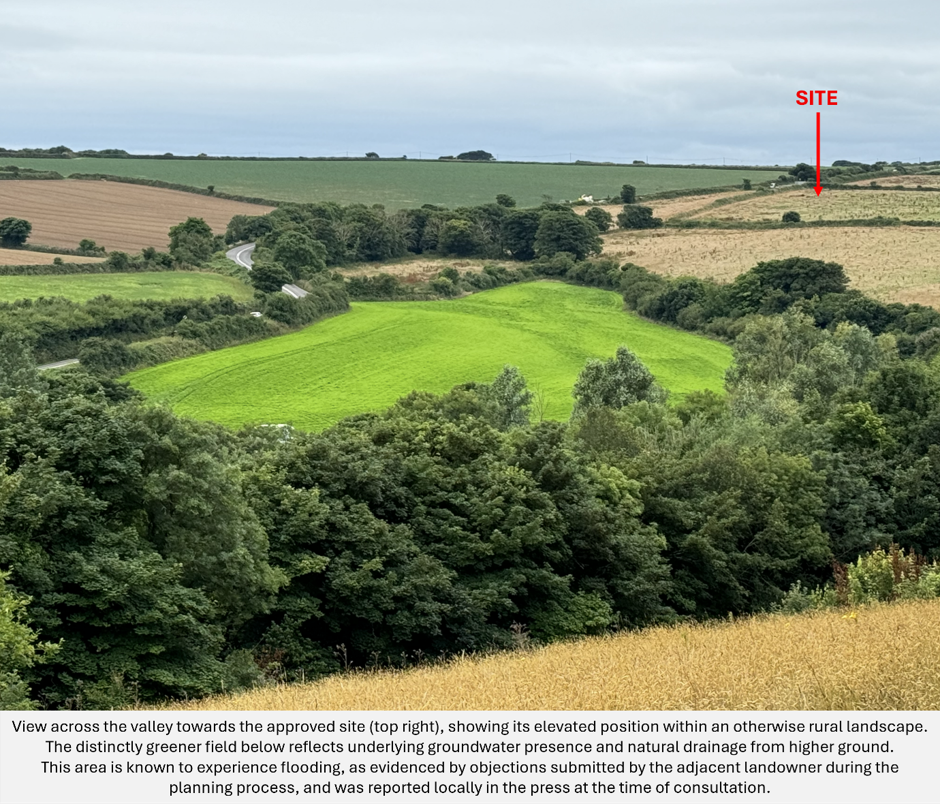
The field shown above is known to flood, while homes, farmland, watercourses, wildlife and the wider Red River catchment lie hostage further along the connected landscape below.
THIS IS THE REAL SOURCE–PATHWAY–RECEPTOR STORY THE APPLICANT’S INDIVIDUAL REPORTS NEVER CONFRONT AS A WHOLE.
Millions of litres of dirty water would be collected, stored, transferred and reused at source, including regular spraying across the site on an elevated industrial waste site.
Gravity, run-off, infiltration and groundwater provide the potential pathways.
The valley and waterways below leading to the sea contain the undeniable receptors.
SOURCE.
PATHWAY.
RECEPTOR.
EVERY ENVIRONMENTAL RISK BEGINS WITH THESE THREE LINKS.