THERE IS NO SAFE INDUSTRIAL ROUTE TO THIS SITE
Whichever way the lorries come, they magnify risks already built into the roads themselves
Roseworthy Hill, the principal HGV route from Camborne West, climbs from the Roseworthy dip towards the approved site.
The road itself is physically hostile to anyone outside a vehicle.
A narrow, twisting 60 mph route enclosed by high hedges and trees, with sharp blind bends, double solid white lines, no pavement, no safe passing places and no lighting.
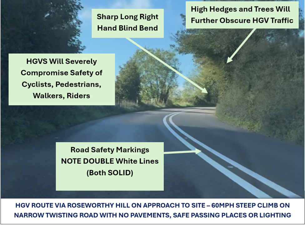
A pedestrian, cyclist or rider meeting an HGV here is not simply “sharing the road”.
They can find themselves trapped in the same narrow carriageway with nowhere safe to go.
How safe is that?
And this is not language imposed on the applicant’s evidence after the event.
Their own Transportation Advisory Note itself says Roseworthy Hill is subject to the 60 mph national speed limit and is “devoid of both verges, footways and street lighting”.
Yet it then concludes that the access is safe and suitable and will not endanger highway users.
It even says staff will be encouraged to travel sustainably — including to cycle — despite its own description of a road with no verge, no footway and no lighting.
The operation would bring hugely increased and sustained HGV traffic onto roads already narrow, unlit, constrained and accident-prone.
THE CONCERN IS NOT SIMPLY EXTRA VEHICLE MOVEMENTS.
It is industrial traffic serving a regional waste operation through rural roads, villages and school-run routes that were never designed for it.
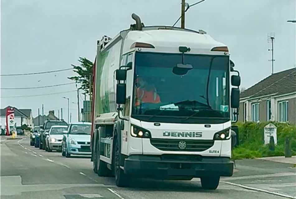
Connor Downs - More Waste HGVs Mean More Congestion
From the west, Loggans Moor Roundabout, the danger changes, but is no less real.
The next alternative approach passes through Connor Downs — a busy, living village of homes, parked cars and constrained widths, with an older people’s home close to the route and a primary-school community where young children walk and cycle.
At multiple points, width restrictions and parked vehicles narrow the available carriageway.
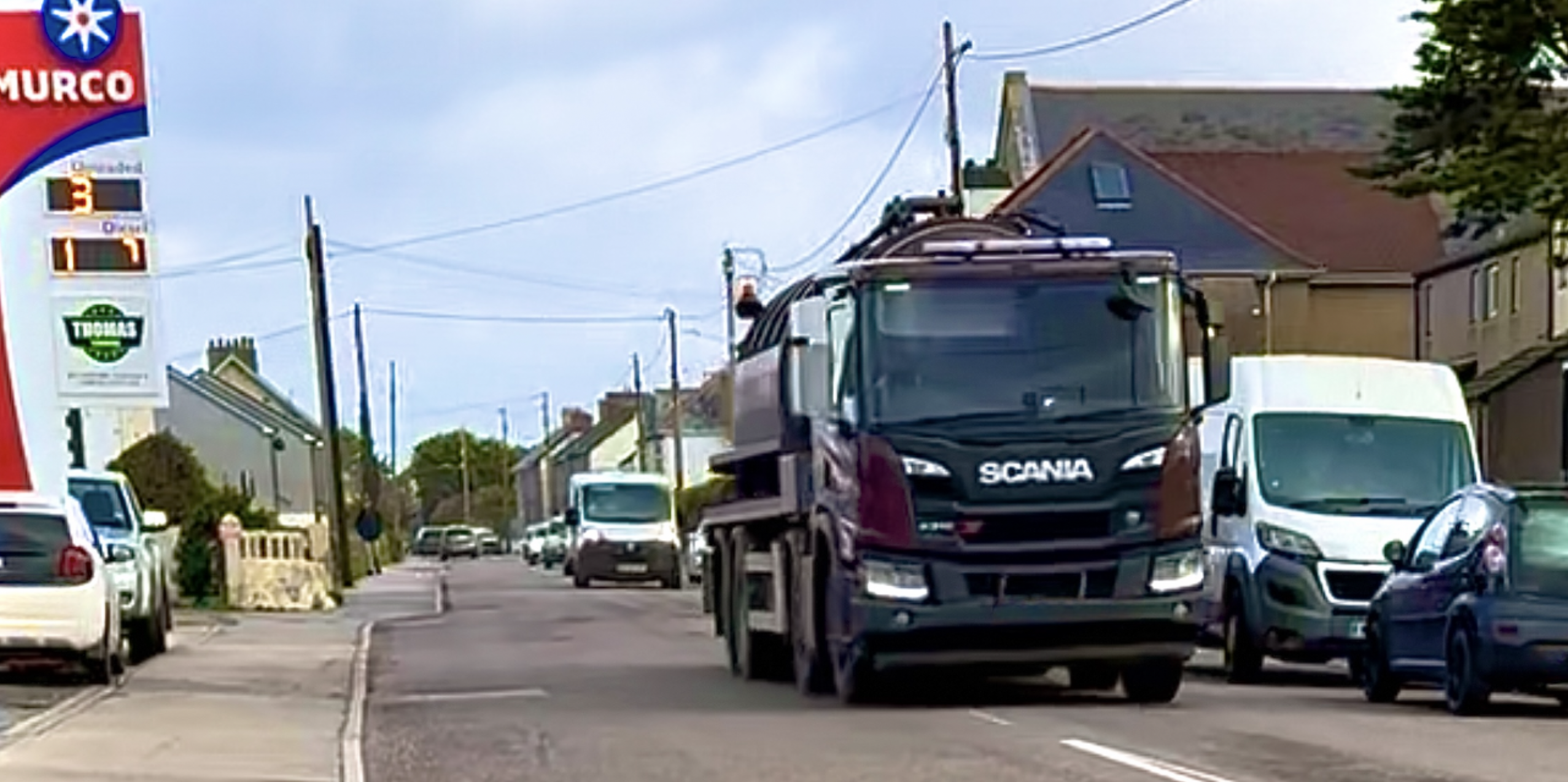
Connor Downs - The Roads Don't Get Any Wider
Forcing traffic into the opposing lane or onto kerbs.
Beyond the village lies the Horsepool Road crossroads and then the steep descent towards the approved site. Drivers leave the 30 mph limit and accelerate towards 60 mph.
The site entrance below still cannot be seen.
THERE IS NO BENIGN APPROACH.
THE DANGERS SIMPLY CHANGE DEPENDING ON WHICH WAY A VEHICLE COMES.
AND THE COLLISION HISTORY WAS ALREADY KNOWN…
CrashMap data submitted during consultation showed multiple historic collisions along the designated and potential routes to and from the site.
Between 2017 and 2024 alone — a period that included the pandemic years of reduced road use — the recorded history included fatalities and numerous serious accidents. On the immediate approach from Roseworthy Hill, a young motorcyclist suffered life-changing injuries in a three-vehicle collision in 2017, while serious accidents were recorded at or very close to the site entrance in 2018 and 2020.
The collision record was put before the decision-maker alongside the physical road geometry and photographic evidence.
Yet in June 2026, the danger returned.
Sadly, two young children were tragically killed in a major collision on the A30 between Camborne West and Loggans Moor, very close to the approved site field. The A30 road remained closed until the following morning while air ambulances, emergency doctors, police and other responders attended, with local and Friday holiday-changeover traffic overwhelming the surrounding network. Roseworthy Hill was clogged with stationary traffic.
Only three weeks later, another collision closed the road at the Horsepool Road crossroads just east of Connor Downs — at the top of the very hill that steeply descends towards the approved site entrance. This crash was a fresh instance of a known hazard, not an isolated event on an otherwise safe road.
BUT THE RISK IS NOT SIMPLY TRAFFIC TRAVELLING ALONG ROSEWORTHY HILL.
IT IS WHAT THOUSANDS UPON THOUSANDS OF LARGE, HEAVILY LADEN VEHICLES MUST ACTUALLY DO EACH YEAR WHEN THEY REACH THE SITE.
They must rapidly decelerate, stop, queue, swing across the carriageway and cross live opposing traffic to enter and then leave a concealed industrial access on a steep hill.
That manoeuvre itself creates the obstruction.
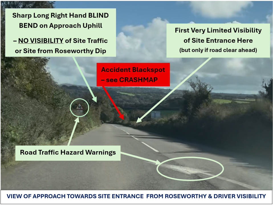
And the narrow site access assumes simultaneous lorry movements into and out of the site.
Approaching from the east, drivers round a sharp blind bend at up to 60 mph with no prior view of the site, the entrance or traffic waiting to turn.
The unseen hazard may be a slow-moving HGV, a stationary laden lorry waiting for a gap in opposing traffic, or a queue formed behind it on the incline. Most site HGVs approaching by the principal route must turn right across downhill traffic to enter.
When leaving, their size and turning circle require large vehicles to pull out across the carriageway to turn back towards Roseworthy.
These are not quick, incidental movements.
They are repeated manoeuvres by long, heavy vehicles traversing and obstructing live traffic on a road of steep gradients, blind bends and restricted sightlines.
Precisely these risks were identified in evidence submitted during consultation before permission was granted.
Approaching from the west via Connor Downs, the danger is reversed but no less serious.
Drivers leave the 30 mph restriction and accelerate towards 60 mph down a steep hill while bends and road gradient still obscure the entrance below.
Again, the unseen hazard may be a stationary or slow-moving HGV, queued traffic or a large vehicle already swinging across the carriageway.
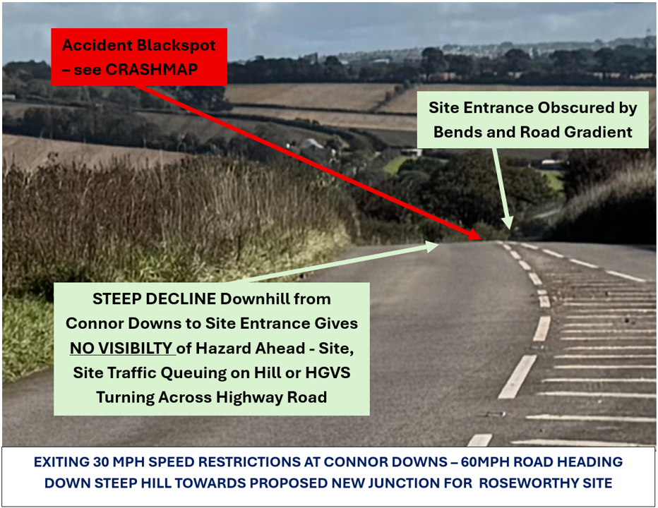
THIS IS HOW THE DEVELOPMENT MAGNIFIES AN ALREADY DANGEROUS ROAD.
IT DOES NOT MERELY ADD EXPONENTIALLY MORE VEHICLES.
IT REPEATEDLY CREATES NEW SLOW-MOVING AND STATIONARY HAZARDS AT THE PRECISE POINT WHERE APPROACHING DRIVERS MAY NOT BE ABLE TO SEE THEM.
However, the applicant’s traffic assessment does not confront that lived reality as a whole.
The traffic assessment’s movement profile was extrapolated from outdated 2018/19 data from the existing smaller Splattenridden operation rather than based on an independent Roseworthy traffic survey.
The assumed underlying movement figures came from 2018/19 — already more than six years old by the time permission was granted — and related to a different site.
They were obsolete as a measure of current traffic demand.
The applicant’s own later material shows why that matters.
The 2019 TAN described the business as having diverted “over 380,000 tonnes” of material from landfill to date. By the later 2024 TAN, that figure had risen to “well over 500,000 tonnes” — at least another 120,000 tonnes handled in the intervening period.
YET THE TRAFFIC CASE FOR ROSEWORTHY REMAINED ROOTED IN HISTORIC MOVEMENT DATA EXTRAPOLATED FROM SPLATTENRIDDEN.
And we now know that Splattenridden is to close, so all of that traffic will also be headed to Roseworthy. This is likely to increase the volume of traffic through Connor Downs significantly.
Nor is business growth the only pressure.
Government policy is driving increased separation and collection of organic waste, expanding the volumes that must be collected, transported and processed.
This is a sector being directed to handle more material, not less.
Even the applicant’s own obsolete figures show the seasonal pressure reality: movements rise from 663 in December to 1,240 in August — almost double, precisely when Cornwall’s roads are carrying intense summer and holiday traffic.
And those large lorries and trucks will not arrive in a calm, evenly spaced procession.
Multiple heavily laden waste vehicles can arrive together, queue, turn across opposing traffic and meet tractors, buses, cars, cyclists and pedestrians on roads where safe passing is already difficult.
These risks were also expressly raised during consultation.
Yet at the Committee meeting itself, highway risk was reduced to a striking assumption: this road used to be the A30, therefore it must still be capable of carrying the traffic.
One Member said it had been “quite capable of carrying traffic when it was the A30” and was “still quite capable” now. Another expressly admitted, “I don’t know the area that well”, but nevertheless said he would “suspect if it’s the old A30 it’s going to be able to cope with the traffic”.
Both voted to approve the development. The latter Member seconded the motion for approval.
Those assumptions had already been directly challenged in evidence submitted during consultation.
This “quite capable” C-road may be colloquially called the “old A30”, but it has always been a narrow, twisting road whose origins lie in the old stagecoach route.
The modern Hayle bypass opened in 1985 after the former route was already struggling with increasing traffic, deliberately taking heavy and through traffic away from vulnerable rural roads and communities.
FORTY YEARS LATER, ITS HISTORIC LABEL DOES NOT MAKE IT SUITABLE FOR AN EVER-GROWING INDUSTRIAL WASTE OPERATION.
Calling it the “old A30” does not widen the blind bends. It does not create pavements, verges or refuges. It does not remove the steep gradients or double white lines. It does not make the concealed site entrance visible. And it does not give a pedestrian somewhere to go when a modern HGV bears down on them.
HISTORY IS NOT A HIGHWAY SAFETY ASSESSMENT
EVERY ADDITIONAL HGV CHANGES THE RISK AROUND IT…
A pedestrian with nowhere to step aside.
A child cycling or walking to school.
An elderly person trying to cross the road.
A horse meeting an air-braked waste vehicle.
A tractor and HGV trying to pass.
A resident pulling out from a concealed entrance.
A bus stopping on a constrained road.
A car forced across the centre line.
An ambulance attempting to move through diverted stationary traffic when the A30 is closed.
A laden lorry slowing sharply to turn across live traffic into a concealed industrial entrance.
This is the reality.
This is what cumulative highway risk means here.
Not one vehicle on one swept-path desk drawing, but thousands upon thousands of additional interactions between large industrial vehicles and everyone else already using roads.
With almost no margin for error.
The TAN does not make the missing pavements appear. It does not widen the blind bends. It does not create refuges for walkers, cyclists or riders. It does not remove the steep gradients, the 60 mph approaches, the village pinch points or the consequences when the A30 closes.
It simply adds the development’s traffic to the jeopardy.
The result?
MORE DIESEL. MORE JOURNEYS. MORE POTHOLES.
MORE AND MORE AND MORE HGVs.
THE ROADS DON’T GET ANY WIDER.