MOST PEOPLE UNDERSTAND THAT CORNWALL’S ARSENIC AND HEAVY-METAL LEGACY SETS IT APART FROM MOST OF THE UK
What happens when you disturb them?
But to understand just how unusual that is, the comparison really matters.
Arsenic in uncontaminated soils globally is typically measured in single figures — around 5–6 mg/kg. Across UK soils, reported concentrations range around 2–53 mg/kg, with a median of about 10 mg/kg.
BUT CORNWALL IS DIFFERENT. IT IS A BREED APART.
Even away from former mining activity, Cornish soils have been reported at around 26–67 mg/kg of arsenic.
In mining-affected areas around Camborne, Redruth and Hayle, sampled topsoil concentrations have reached around 727 mg/kg.
AND THEN THERE IS ROSEWORTHY…
Peer-reviewed research by scientists from the Camborne School of Mines investigated this very locality.
Click this link to read the academic research.
They found arsenic in soils here at up to 4,466 mg/kg.
More than six times the already extreme levels recorded in those other mining-affected Cornish areas.
And around 800 times the typical concentrations found in ordinary soils elsewhere in the world.
At the historic New Mill arsenic works, in the same part of Roseworthy locality as the site, where arsenic-bearing ores were once processed in calciners, waste material was found to contain arsenic at levels of up to around 15% of the material itself.
The scientists’ conclusion was stark: the New Mill area was “severely contaminated by arsenic”.
THIS IS THEREFORE NOT SIMPLY “HIGH FOR CORNWALL”.
IT IS OFF THE SCALE — AND EXTRAORDINARY EVEN HERE.
And this contamination is not confined to the historic arsenic works themselves.
Even the applicant’s own investigation report confirmed elevated arsenic in the soils of the approved development site itself.
Its ten composite soil samples taken from the site field recorded concentrations of up to 200 mg/kg, around three times even the upper end of levels reported in Cornish soils away from former mining activity.
For context, 200 mg/kg is more than five times the published 37 mg/kg screening level used for arsenic in residential soils with home-grown produce in England.
Cornwall Council itself recognises land contamination as a planning issue that requires investigation and potential remediation before development can safely proceed.
Yet the applicant assessed this rural agricultural field solely in the context of its proposed future use as a “commercial/industrial development”.
The applicant’s own consultant went further still.
They concluded that fugitive dust from the nearby historic arsenic calciner had already significantly impacted soils on the development site itself.
In other words:
THE HISTORIC CONTAMINATION IS VERY REAL AND HAS ALREADY TRAVELLED AT LEAST HALF A KILOMETRE FROM ITS SOURCE.
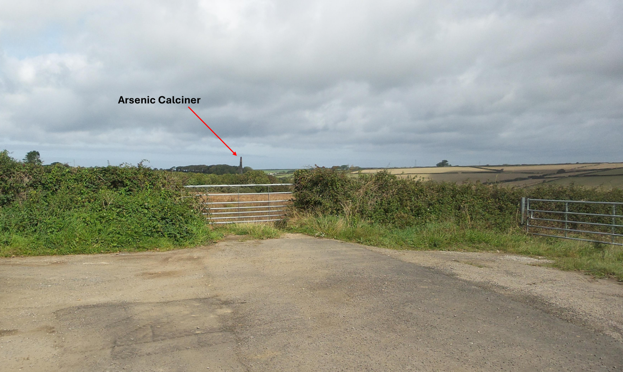
Roseworthy arsenic calciner, Scheduled Monument, as seen from the site entrance
SO WHAT EXACTLY WAS TESTED — AND HOW DEEP?
On 31 March 2025, a dated photograph submitted in objection records the site and adjoining fields being actively ploughed and prepared by two tractors.
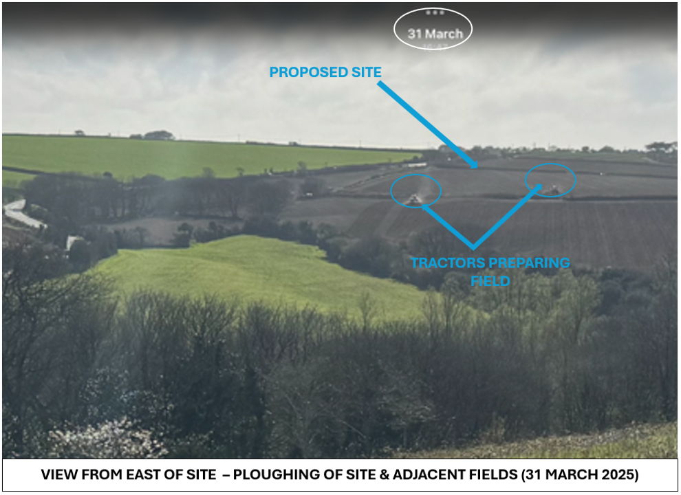
Until then, the land had lain untended and fallow for a number of years. It was subsequently cultivated and reseeded. By 16 June, the applicant’s own Visual Impact Assessment photograph shows the greened surface.
The contamination sampling came later.
On 14 and 15 July 2025, thirty hand-dug pits were excavated across the site — each only 0.4 metres deep. Material from groups of three separate pits was then mixed to produce just ten composite samples for laboratory analysis.
FORTY CENTIMETRES. ABOUT THE DEPTH OF THE RECENTLY WORKED AGRICULTURAL SOIL.
Yet even those shallow composite samples recorded arsenic at up to 200 mg/kg.
And the significance of the recent ploughing is not merely speculative. Respected peer-reviewed research into this very locality had already concluded that “agricultural disturbance by ploughing and down-slope leaching has probably dispersed the arsenic contamination in the soil.”
This sequence matters.
The upper soil profile had been ploughed, cultivated and reseeded before thirty shallow pits were dug to just 0.4 metres and combined into ten composite samples.
Because three separate sampling locations were mixed into each laboratory sample, any individual local variations between them were obscured — including potential hotspots of materially higher contamination.
And even then, arsenic was still recorded at up to 200 mg/kg.
Now compare what was tested with what has actually been approved.
TESTED DEPTH: 0.4 metres.
APPROVED CUT: approximately 2.5 metres in places — more than six times deeper.
APPROVED FILL: around 4 metres in lower areas.
The applicant’s own cut-and-fill plan calculates approximately 22,511 cubic metres of excavation and 27,134 cubic metres of fill across almost 3.3 hectares of newly engineered ground.
MORE THAN 49,000 CUBIC METRES OF EARTH TO BE CUT OR FILLED ACROSS A CONTAMINATED FORMER MINING LANDSCAPE.
In other words, the deeper ground — the very ground that construction will actually cut into — was not sampled for contamination.
AND THIS IS WHERE THE PEER-REVIEWED RESEARCH FROM THE CAMBORNE SCHOOL OF MINES BECOMES IMPOSSIBLE TO IGNORE.
The researchers found most of the arsenic contamination in the silt and sand fractions. Their findings were clear: while the elevated arsenic showed relatively low mobility under the conditions measured at the time, change those conditions at all and their warning becomes ominous. They identified a “large reservoir of arsenic” that could be remobilised if ambient conditions changed, with potential “retoxification of the site.”
A LARGE RESERVOIR OF ARSENIC.
CAPABLE OF BEING REMOBILISED IF CONDITIONS CHANGE.
THEIR WORD WAS “RETOXIFICATION”.
And despite these peer-reviewed scientific findings being repeatedly brought to the Council’s attention through numerous objections, the Council has now granted permission to cut approximately 2.5 metres into this hillside for extensive excavation, move tens of thousands of cubic metres of ground, and radically and irreversibly alter the physical and drainage conditions of the site.
With disregard for the repeated warnings arising from the Camborne School of Mines research.
If that is not a change in conditions, what is?
THIS IS NOT A SPADE IN A FIELD.
IT IS INDUSTRIAL-SCALE DISTURBANCE OF A CONTAMINATED FORMER MINING LANDSCAPE.
And the applicant’s own Ground Quality Risk Assessment adds yet another striking detail.
It says a suitable Safe System of Work — including the use of PPE — would be required to protect workers from heavy-metal contamination during both the construction phase and operation thereafter.
Not just while the ground is being dug up. During ongoing operation too.
Yet the same assessment judged the soils acceptable in the context of a “commercial/industrial development”.
BUT THIS IS NOT AN EXISTING INDUSTRIAL SITE.
It is an agricultural field on a rural, windy ridge, hugged by food-producing land and close to homes, gardens and communities.
There is no industrial development around it. None anywhere near it.
The Council condition specifies that construction work is to cease in any part of the site where contamination is found and risk assessments carried out – by which time it is already too late to prevent its disturbance.
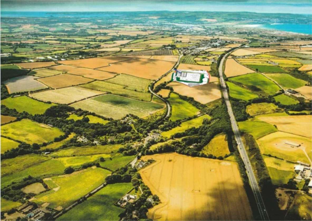
Aerial view of the Roseworthy Valley with approved industrial development plan superimposed.
THE “COMMERCIAL/INDUSTRIAL” CONTEXT IS NOT WHAT THIS PLACE IS.
IT IS WHAT THIS PERMISSION WOULD TURN ONE PART OF IT INTO. PERMANENTLY.
And everything beyond that new “industrial” boundary remains exactly where it was. What about the risks of heavy metal contamination to everything beyond it?
The people remain.
The crops remain.
The homes remain.
The gardens remain.
The wildlife remains.
The aquifers, streams and rivers remain.
The valley remains.
But dust and water do not respect labels. They do not remain inside a future land-use category.
THE QUESTION IS NOT WHETHER ARSENIC AND HEAVY METALS EXIST HERE.
They categorically do.
In exceptional quantities.
THE REAL QUESTION IS WHAT HAPPENS WHEN CONTAMINATED GROUND IN THIS EXCEPTIONAL FORMER MINING LANDSCAPE IS CUT OPEN, EXCAVATED, MOVED AND RADICALLY RE-ENGINEERED?